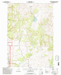
1992 Map of Brewer Reservoir
USGS Topo · Published 1997About this map
The Hay Creek Ranch occupies the northern drainage of this Jefferson County landscape, where the ranching economy has long relied on the seasonal flows of Hay Creek and Anderson Springs. In the western reaches, the Crooked River National Grassland encompasses a transition from the drainage of Willow Creek to the prominent rising terrain of the Baldwin Hills. This area is defined by its water management and grazing infrastructure, evidenced by Storage Bins and a network of named springs that supported livestock in the high desert environment. The presence of Brewer Reservoir and various landmarks like Morrow Well and a Drill Hole reflect the mid-century efforts to manage subsurface and surface water resources. Tracing Grizzly Road across the southern half of the quadrangle shows the primary access route through this terrain of steep cuts like Dewies Canyon and Wagonblast Canyon.
Find a feature on this map
22 named features on this map. Tap any name to fly to it.
Don’t see what you’re looking for? This feature index may not catch every label — zoom into the map to look around manually.
Map Details
Editions of this 1992 Brewer Reservoir Map
This is the sole edition of this map. No revisions or reprints were ever made.
Other maps of this area

1926 · Bend
USGS Topo · 1:125,000

1928 · Madras
USGS Topo · 1:125,000

1929 · Bend
USGS Topo · 1:125,000

1931 · Madras
USGS Topo · 1:125,000

1955 · Bend
USGS Topo · 1:250,000

1957 · Bend
USGS Topo · 1:250,000

1958 · Bend
USGS Topo · 1:250,000
1962 · Gray Butte
USGS Topo · 1:24,000

1962 · Prineville
USGS Topo · 1:62,500
1963 · Madras East
USGS Topo · 1:24,000