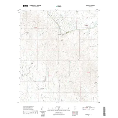
2018 Map of Brewersville
USGS Topo · Published 2018About this map
Brewersville and its surrounding rural landscapes in Sumter County are defined by the winding course of the Tennessee-Tombigbee Waterway. This 2018 survey reveals a terrain transitioning from the marshy lowlands of Charleston Swamp and Caney Slough to the prominent river elevations of Buzzard Roost Bluff. Small, scattered communities like Bluffport and Moore Town are linked by a network of county roads and family-named routes, such as Moore Place Rd and Lewis Miles Ln, reflecting the enduring agricultural and residential patterns of the region. Local history is anchored by numerous family and community burial grounds, including the Saint Matthew Cem, Phares Cem, and Brewersville Cem. The map provides a contemporary view of the intersection between Greene and Sumter counties, where the waterway remains the dominant geographical feature.
Find a feature on this map
72 named features on this map. Tap any name to fly to it.
Don’t see what you’re looking for? This feature index may not catch every label — zoom into the map to look around manually.
Map Details
Editions of this 2018 Brewersville Map
This is the sole edition of this map. No revisions or reprints were ever made.
Other maps of this area

1929 · Epes
USGS Topo · 1:48,000

1932 · Epes
USGS Topo · 1:62,500

1947 · Forkland
USGS Topo · 1:24,000

1948 · Mc Dowell
USGS Topo · 1:24,000

1949 · Mc Dowell
USGS Topo · 1:24,000

1949 · Forkland
USGS Topo · 1:24,000

1953 · Montgomery
USGS Topo · 1:250,000

1953 · Meridian
USGS Topo · 1:250,000

1956 · Montgomery
USGS Topo · 1:250,000

1957 · Meridian
USGS Topo · 1:250,000