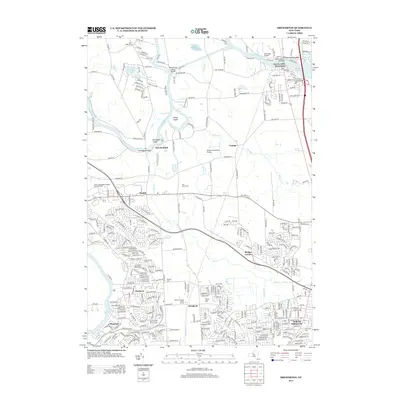
2013 Map of Brewerton
USGS Topo · Published 2013About this map
Oneida River and Oneida Lake dominate the northern landscape of this Onondaga County region, where the historic crossroads of Brewerton and Oak Orchard maintain their positions along the water. The suburban expansion of North Syracuse and Bayberry is evident in the south, yet the central portion remains characterized by drainage patterns like Mud Cr and the island-dotted river channel featuring Denmans Island and Glosky Island. Genealogists will find several burial grounds including Sand Ridge Cem and Pine Plains Cem spread across the township.
Find a feature on this map
299 named features on this map. Tap any name to fly to it.
Don’t see what you’re looking for? This feature index may not catch every label — zoom into the map to look around manually.
Map Details
Editions of this 2013 Brewerton Map
This is the sole edition of this map. No revisions or reprints were ever made.
Other maps of this area

1895 · Syracuse
USGS Topo · 1:62,500

1898 · Syracuse
USGS Topo · 1:62,500

1900 · Baldwinsville
USGS Topo · 1:62,500

1900 · Fulton
USGS Topo · 1:62,500

1905 · Mexico
USGS Topo · 1:62,500

1938 · Syracuse East
USGS Topo · 1:24,000

1939 · Syracuse West
USGS Topo · 1:24,000

1940 · Brewerton
USGS Topo · 1:24,000

1940 · Cicero
USGS Topo · 1:24,000
1943 · Syracuse East
USGS Topo · 1:31,680