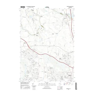
2016 Map of Brewerton
USGS Topo · Published 2016About this map
The Oneida River flows westward from Oneida Lake at Brewerton, forming the winding border between Oswego and Onondaga Counties. This central New York landscape is defined by its complex hydrology, where Peat Swamp and numerous seasonal creeks like Shaver Cr and Youngs Cr intersect with the expanding suburban footprints of Clay and North Syracuse. To the west, the Seneca River meets the Oneida, creating a network of islands including Schroeppel Island and Glosky Island. Genealogists will find several significant burial sites, from the Riverside Cem near the riverbanks to the more inland Morgan's Cem and Pine Plains Cem. The transition from rural crossroad settlements like Euclid and Rodger Corner to modern developments is visible through the dense local road network and the presence of the Bryant and Stratton Coll Liverpool Campus.
Find a feature on this map
220 named features on this map. Tap any name to fly to it.
Don’t see what you’re looking for? This feature index may not catch every label — zoom into the map to look around manually.
Map Details
Editions of this 2016 Brewerton Map
This is the sole edition of this map. No revisions or reprints were ever made.
Other maps of this area

1895 · Syracuse
USGS Topo · 1:62,500

1898 · Syracuse
USGS Topo · 1:62,500

1900 · Baldwinsville
USGS Topo · 1:62,500

1900 · Fulton
USGS Topo · 1:62,500

1905 · Mexico
USGS Topo · 1:62,500

1938 · Syracuse East
USGS Topo · 1:24,000

1939 · Syracuse West
USGS Topo · 1:24,000

1940 · Brewerton
USGS Topo · 1:24,000

1940 · Cicero
USGS Topo · 1:24,000
1943 · Syracuse East
USGS Topo · 1:31,680