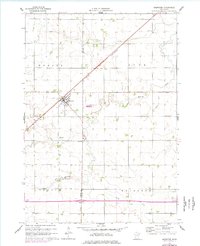
1960 Map of Brewster
USGS Topo · Published 1977About this map
The agricultural landscape of Nobles and Jackson Counties is anchored by Brewster, a prairie settlement defined by the diagonal transit of the Chicago and North Western railroad. This survey, based on 1958 photography and 1960 field checks, captures the area before modern interstate expansion significantly altered the local road patterns. The drainage of the till plain is managed by a network of engineered waterways, including Judicial Ditch No 76 and Judicial Ditch No 84, which supplement the natural courses of Okabena Creek and Elk Creek. Local history and genealogy interests are centered on sites such as Trinity Cem and Hersey Cem, while the presence of a Townhall and scattered Sandpits reflect the civic and extractive activities of the rural townships including Hersey and Alba.
Find a feature on this map
17 named features on this map. Tap any name to fly to it.
Don’t see what you’re looking for? This feature index may not catch every label — zoom into the map to look around manually.
Map Details
Editions of this 1960 Brewster Map
2 editions found
Other maps of this area

1954 · Fairmont
USGS Topo · 1:250,000

1958 · Fairmont
USGS Topo · 1:250,000

1960 · Brewster
USGS Topo · 1:24,000

1960 · Okabena
USGS Topo · 1:24,000

1960 · Worthington North
USGS Topo · 1:24,000

1960 · Worthington South
USGS Topo · 1:24,000

1960 · Round Lake
USGS Topo · 1:24,000

1960 · Sioux Valley
USGS Topo · 1:24,000

1970 · Dundee
USGS Topo · 1:24,000

1970 · Fulda
USGS Topo · 1:24,000