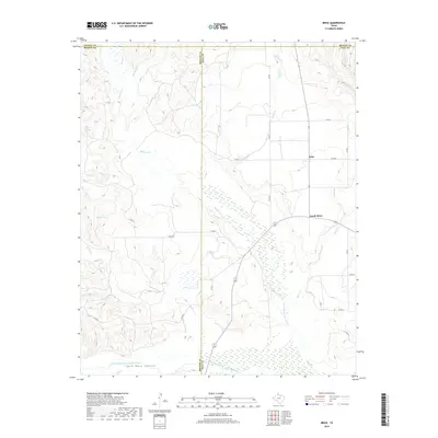
2019 Map of Brice
USGS Topo · Published 2019About this map
Palo Duro Canyon anchors the southern reaches of this landscape, where the Prairie Dog Town Fork Red River flows through a network of drainage systems and rugged breaks. The rural community of Brice and the nearby South Brice sit atop the high plains, serving as the primary points of settlement in this part of Hall County. A complex web of watercourses, including Mulberry Cr, Bitter Cr, and Brushy Cr, dissects the terrain, illustrating the dramatic erosive power of the Panhandle environment. To the west, the presence of Timber Lake and Sink Lake provides a contrast to the dry creek beds and canyon floor, marking distinctive hydrological features in an otherwise arid region. The map highlights the intersection of Briscoe, Donley, and Hall counties, where an extensive system of county roads, such as Co RD 34 and Co RD D, connects the dispersed homesteads and ranch lands across the caprock.
Find a feature on this map
27 named features on this map. Tap any name to fly to it.
Don’t see what you’re looking for? This feature index may not catch every label — zoom into the map to look around manually.
Map Details
Editions of this 2019 Brice Map
This is the sole edition of this map. No revisions or reprints were ever made.
Other maps of this area

1954 · Plainview
USGS Topo · 1:250,000

1958 · Plainview
USGS Topo · 1:250,000

1960 · Indian Peak
USGS Topo · 1:62,500

1960 · Brice
USGS Topo · 1:62,500

1963 · Clarendon SE
USGS Topo · 1:24,000

1963 · Tate Arroyo
USGS Topo · 1:24,000

1963 · Clarendon SW
USGS Topo · 1:24,000

1976 · Brice SE
USGS Topo · 1:24,000

1976 · Brice NW
USGS Topo · 1:24,000
1976 · Indian Peak NE
USGS Topo · 1:24,000