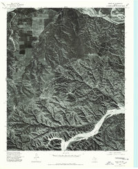
1976 Map of Brice SW
USGS Topo · Published 1978About this map
Little Red River flows across the southern reaches of this landscape, a stark contrast to the intricate canyon-cut terrain of Hall County. This 1976 orthophotoquad reveals the intricate erosional patterns of the Texas Panhandle, where the high plains break away into a labyrinth of drainage channels. In the north, the Prairie Dog Town Fork Red River forms a wide, sandy corridor, typical of the braided river systems in this region. The imagery highlights the stark boundary between the geometric precision of upland agricultural fields in the northwest and the untamed, deeply dissected breaks that dominate the eastern and southern portions of the quadrangle. These aerial photographs provide a clear view of the land use and natural topography before modern developments altered the rural character of the area.
Find a feature on this map
2 named features on this map. Tap any name to fly to it.
Don’t see what you’re looking for? This feature index may not catch every label — zoom into the map to look around manually.
Map Details
Editions of this 1976 Brice SW Map
This is the sole edition of this map. No revisions or reprints were ever made.
Other maps of this area

1954 · Plainview
USGS Topo · 1:250,000

1958 · Plainview
USGS Topo · 1:250,000

1960 · Indian Peak
USGS Topo · 1:62,500

1960 · Brice
USGS Topo · 1:62,500

1967 · Tampico Siding
USGS Topo · 1:24,000

1967 · Turkey
USGS Topo · 1:24,000

1967 · Lake Theo
USGS Topo · 1:24,000

1976 · Brice SE
USGS Topo · 1:24,000

1976 · Brice NW
USGS Topo · 1:24,000
1976 · Indian Peak NE
USGS Topo · 1:24,000