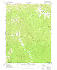
1969 Map of Briceland
USGS Topo · Published 1974About this map
The Mattole River headwaters define the character of this 1969 field-checked survey, winding through the timber-rich terrain of southern Humboldt County. Small settlements like Briceland and Whitethorn serve as local hubs, connected by winding routes like Shelter Cove Road and Corral Road. The landscape is dominated by significant elevation changes, from the heights of Rose Peak and Telegraph Ridge to the protected lands within the King Range National Conservation Area. Notable infrastructure includes the Thorn Fire Control Station at Thorn Junction and a Gas Well near Briceland. Numerous drainage features such as West Fork Sproul Creek, Whale Gulch, and Redwood Creek cut through the prominent Gibson Ridge, illustrating the complex watershed system that feeds into the Mattole.
Find a feature on this map
42 named features on this map. Tap any name to fly to it.
Don’t see what you’re looking for? This feature index may not catch every label — zoom into the map to look around manually.
Map Details
Editions of this 1969 Briceland Map
4 editions found
Other maps of this area

1920 · Pt. Delagda
USGS Topo · 1:62,500

1921 · Briceland
USGS Topo · 1:62,500

1949 · Eureka
USGS Topo · 1:250,000

1949 · Point Delgada
USGS Topo · 1:62,500

1949 · Garberville
USGS Topo · 1:62,500

1950 · Piercy
USGS Topo · 1:62,500

1951 · Garberville
USGS Topo · 1:62,500

1951 · Point Delgada
USGS Topo · 1:62,500

1957 · Ukiah
USGS Topo · 1:250,000

1958 · Redding
USGS Topo · 1:250,000