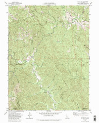
1969 Map of Briceland
USGS Topo · Published 1987About this map
The Mattole River snakes through the dense southern Humboldt County landscape in this late 1960s survey, anchoring a region of steep ridges and small timber-and-ranching outposts. The settlement of Briceland sits in the northeast corner near a Gas Well and Briceland Creek, while the village of Whitethorn serves the southern valley along with the Whitethorn Sch. This era captures the area just as the King Range National Conservation Area was established, marking a shift toward formal land management along the rugged Lost Coast interior.
Find a feature on this map
45 named features on this map. Tap any name to fly to it.
Don’t see what you’re looking for? This feature index may not catch every label — zoom into the map to look around manually.
Map Details
Editions of this 1969 Briceland Map
4 editions found
Other maps of this area

1920 · Pt. Delagda
USGS Topo · 1:62,500

1921 · Briceland
USGS Topo · 1:62,500

1949 · Eureka
USGS Topo · 1:250,000

1949 · Point Delgada
USGS Topo · 1:62,500

1949 · Garberville
USGS Topo · 1:62,500

1950 · Piercy
USGS Topo · 1:62,500

1951 · Garberville
USGS Topo · 1:62,500

1951 · Point Delgada
USGS Topo · 1:62,500

1957 · Ukiah
USGS Topo · 1:250,000

1958 · Redding
USGS Topo · 1:250,000