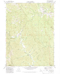
1969 Map of Briceland
USGS Topo · Published 1987About this map
Briceland and Whitethorn serve as the primary human hubs in this 1969 topographical study of southern Humboldt County. The landscape is defined by the winding course of the Mattole River, which cuts through the mountainous terrain between Telegraph Ridge and Gibson Ridge. While the Redwood Highway clips the northeastern corner, the interior is accessed via the winding Shelter Cove Road and numerous trails. The presence of the Whitehorn Sch, a Radio Facility, and the Thorn Fire Control Station indicates the infrastructure required to manage these remote timber and ranching lands. At the western edge, the boundary of the King Range National Conservation Area marks a shift toward protected coastal wilderness, while the southern margin records the jurisdictional line between Humboldt and Mendocino counties. Local water features like Sproul Creek and Whale Gulch drain the high ridges, including Rose Peak, toward the Pacific.
Find a feature on this map
42 named features on this map. Tap any name to fly to it.
Don’t see what you’re looking for? This feature index may not catch every label — zoom into the map to look around manually.
Map Details
Editions of this 1969 Briceland Map
4 editions found
Other maps of this area

1920 · Pt. Delagda
USGS Topo · 1:62,500

1921 · Briceland
USGS Topo · 1:62,500

1949 · Eureka
USGS Topo · 1:250,000

1949 · Point Delgada
USGS Topo · 1:62,500

1949 · Garberville
USGS Topo · 1:62,500

1950 · Piercy
USGS Topo · 1:62,500

1951 · Garberville
USGS Topo · 1:62,500

1951 · Point Delgada
USGS Topo · 1:62,500

1957 · Ukiah
USGS Topo · 1:250,000

1958 · Redding
USGS Topo · 1:250,000