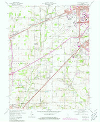
1966 Map of Bridgeport
USGS Topo · Published 1981About this map
Indianapolis International Airport serves as a massive focal point for the southwest corner of the Indianapolis metropolitan area, dominating the landscape between Bridgeport and Seerley. The mapping reveals a region in transition, where established rural communities like West Newton and Camby sit adjacent to the expanding suburban infrastructure and the industrial corridors of the Conrail railroad. The historical footprint of the area is well-preserved through numerous family and community landmarks, including Seerley Cem and the Siloam Cem.
Find a feature on this map
72 named features on this map. Tap any name to fly to it.
Don’t see what you’re looking for? This feature index may not catch every label — zoom into the map to look around manually.
Map Details
Editions of this 1966 Bridgeport Map
4 editions found
Other maps of this area

1948 · Maywood
USGS Topo · 1:24,000

1948 · Indianapolis West
USGS Topo · 1:24,000

1952 · Bargersville
USGS Topo · 1:24,000

1953 · Bridgeport
USGS Topo · 1:24,000

1953 · Brownsburg
USGS Topo · 1:24,000

1953 · Plainfield
USGS Topo · 1:24,000

1953 · Clermont
USGS Topo · 1:24,000

1953 · Indianapolis
USGS Topo · 1:250,000

1955 · Mooresville West
USGS Topo · 1:24,000

1955 · Mooresville East
USGS Topo · 1:24,000