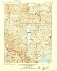
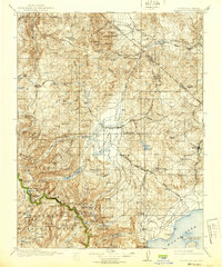
1911 Map of Bridgeport
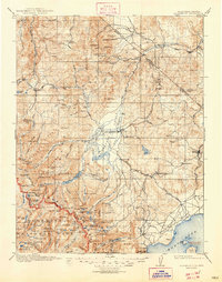
USGS Topo · Published 1951About this map
The High Sierra and the Great Basin converge in this early twentieth-century survey of Mono County, centered on Bridgeport. The landscape is defined by the extraction of mineral wealth and the logistical challenges of the era, seen in the Masonic Pittsburg Liberty Mines and the presence of a Tollhouse on the East Walker River. To the east, the mining town of Bodie stands near the California-Nevada boundary, while the Sweetwater Mountains host remote outposts like Belfort and Star City. The map documents a transition in transportation, showing both the Conways Stage Station and the Tioga Lodge Mono Lake P O near the shores of Mono Lake. To the southwest, the boundary of Yosemite National Park marks a jagged line across the peaks of the Sierra Nevada, from Buckeye Pass to Matterhorn Peak.
Find a feature on this map
168 named features on this map. Tap any name to fly to it.
Don’t see what you’re looking for? This feature index may not catch every label — zoom into the map to look around manually.
Map Details
Editions of this 1911 Bridgeport Map
7 editions found

Other maps of this area

1889 · Markleeville
USGS Topo · 1:125,000

1891 · Markleeville
USGS Topo · 1:125,000

1891 · Wellington
USGS Topo · 1:125,000

1893 · Markleeville
USGS Topo · 1:125,000

1893 · Wellington
USGS Topo · 1:125,000

1896 · Dardanelles
USGS Topo · 1:125,000

1897 · Yosemite
USGS Topo · 1:125,000

1898 · Dardanelles
USGS Topo · 1:125,000

1900 · Yosemite
USGS Topo · 1:125,000

1901 · Mt. Lyell
USGS Topo · 1:125,000