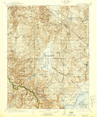
1911 Map of Bridgeport
USGS Topo · Published 1939About this map
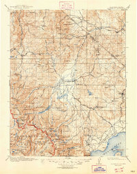
Bridgeport Valley serves as the central focal point of this high-altitude survey, where the East Walker River winds toward the California-Nevada border. This turn-of-the-century landscape is defined by its mining and transport history, documented through remote outposts like Belfort, Masonic, and the high-elevation camp at Lundy. The eastern reaches are dominated by Mono Lake and its distinctive features, Negit Island and Paoha Island, while the western boundary follows the serrated peaks of Yosemite National Park. Notable mining operations including the May Lundy Mine and Dunderberg Mine are marked alongside early transit markers like Conways Stage Station. The map illustrates a complex network of canyons and high-country water bodies, such as Twin Lakes and Peeler Lake, supporting a regional economy transitioning from the peak of the gold and silver era toward more established mountain settlements.
Find a feature on this map
128 named features on this map. Tap any name to fly to it.
Don’t see what you’re looking for? This feature index may not catch every label — zoom into the map to look around manually.
Map Details
Editions of this 1911 Bridgeport Map
7 editions found

Other maps of this area

1889 · Markleeville
USGS Topo · 1:125,000

1891 · Markleeville
USGS Topo · 1:125,000

1891 · Wellington
USGS Topo · 1:125,000

1893 · Markleeville
USGS Topo · 1:125,000

1893 · Wellington
USGS Topo · 1:125,000

1896 · Dardanelles
USGS Topo · 1:125,000

1897 · Yosemite
USGS Topo · 1:125,000

1898 · Dardanelles
USGS Topo · 1:125,000

1900 · Yosemite
USGS Topo · 1:125,000

1901 · Mt. Lyell
USGS Topo · 1:125,000