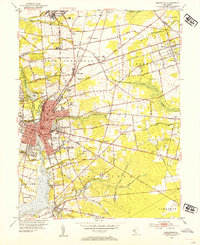
1953 Map of Bridgeton
USGS Topo · Published 1955About this map
Bridgeton stands as a significant industrial and agricultural hub along the Cohansey River in this mid-century survey of Cumberland County. The city’s dense urban grid is surrounded by a network of specialized settlements and processing centers, including the major operations at Seabrook Farms and the smaller hamlets of Gouldtown, Rosenhayn, and Fairton. A complex web of rail infrastructure, featuring the New Jersey Southern Railroad and Pennsylvania-Reading Seashore Lines, highlights the area's role in moving produce and goods from the local fields and mills like Rammel Mill to broader markets.
Find a feature on this map
63 named features on this map. Tap any name to fly to it.
Don’t see what you’re looking for? This feature index may not catch every label — zoom into the map to look around manually.
Map Details
Editions of this 1953 Bridgeton Map
4 editions found
Other maps of this area

1890 · Salem
USGS Topo · 1:62,500

1890 · Bay Side
USGS Topo · 1:62,500

1890 · Bridgeton
USGS Topo · 1:62,500

1890 · Glassboro
USGS Topo · 1:62,500

1894 · Bay Side
USGS Topo · 1:62,500

1894 · Bridgeton
USGS Topo · 1:62,500

1898 · Salem
USGS Topo · 1:62,500

1898 · Glassboro
USGS Topo · 1:62,500

1899 · Vineland
USGS Topo · 1:125,000

1901 · Camden
USGS Topo · 1:125,000