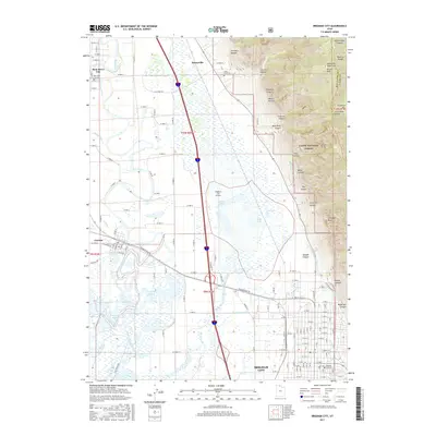
2017 Map of Brigham City
USGS Topo · Published 2017About this map
Brigham City and the surrounding agricultural corridor of Box Elder County are defined by the dramatic transition from the high Wasatch Range to the sprawling wetlands of the Bear River basin. This modern topographic record shows a landscape managed for both industry and conservation, where the N String Irrigation Ditch and Perry Canal distribute water across the valley floor. To the west, the complex hydrology of the Horseshoe Sloughs, Black Slough, and Reeder Overflow reveals the natural drainage patterns that sustain the local ecosystem near the Bird Refuge Rd. Local history is anchored by established settlements like Honeyville and Corinne, while family and community heritage is preserved at sites like the Call's Fort Cem and Brigham City Cem. The eastern mountainside is deeply incised by numerous drainages, including Precipice Canyon and Waterfall Canyon, rising toward Mitton Peak.
Find a feature on this map
60 named features on this map. Tap any name to fly to it.
Don’t see what you’re looking for? This feature index may not catch every label — zoom into the map to look around manually.
Map Details
Editions of this 2017 Brigham City Map
This is the sole edition of this map. No revisions or reprints were ever made.
Other maps of this area

1914 · Logan
USGS Topo · 1:125,000

1916 · Logan
USGS Topo · 1:125,000

1954 · Whistler Canal
USGS Topo · 1:24,000

1954 · Ogden
USGS Topo · 1:250,000

1954 · Brigham City
USGS Topo · 1:250,000

1955 · Mantua
USGS Topo · 1:24,000

1955 · Bear River City
USGS Topo · 1:24,000

1955 · Willard
USGS Topo · 1:24,000

1955 · Mount Pisgah
USGS Topo · 1:24,000

1955 · Brigham City
USGS Topo · 1:24,000