
1953 Map of Brighton
USGS Topo · Published 1954About this map
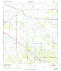
The Brighton Seminole Indian Reservation dominates the southern landscape of this 1950s survey, illustrating a critical era of water management and land use in South Florida. Located along the Highlands Co Glades Co line, the region is defined by a vast network of drainage infrastructure, most notably the Indian Prairie Canal. Extensive earthen works, labeled as Spoil Bank, line the artificial waterways and property lines, signifying the intensive labor required to reclaim and manage this prairie terrain. The small settlement of Brighton sits at a crossroads in the northwest, serving as a primary point of reference in an area otherwise characterized by its scattered Flowing Wells and the clearly marked Reservation Boundary. This topographic study documents the engineering of the Florida interior before later 20th-century developments further altered the natural hydrology.
Find a feature on this map
7 named features on this map. Tap any name to fly to it.
Don’t see what you’re looking for? This feature index may not catch every label — zoom into the map to look around manually.
Map Details
Editions of this 1953 Brighton Map
2 editions found
Other maps of this area

1952 · Okeechobee NW
USGS Topo · 1:24,000

1953 · Brighton NW
USGS Topo · 1:24,000

1953 · Brighton SW
USGS Topo · 1:24,000

1953 · Fort Basinger
USGS Topo · 1:24,000

1953 · Brighton SE
USGS Topo · 1:24,000

1953 · Okeechobee SW
USGS Topo · 1:24,000

1953 · Basinger SW
USGS Topo · 1:24,000

1953 · Taylor Creek SW
USGS Topo · 1:24,000

1956 · Fort Pierce
USGS Topo · 1:250,000

1958 · Fort Pierce
USGS Topo · 1:250,000