
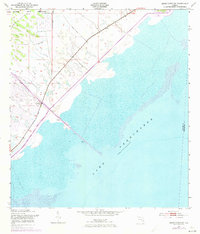
1953 Map of Okeechobee SW
USGS Topo · Published 1954About this map
Lake Okeechobee dominates the southeastern quadrant of this mid-century survey, revealing a landscape defined by massive water management efforts in the Florida Everglades. The northwestern shore is heavily engineered, featuring a prominent Levee and Spoil Bank system designed to contain the lake's seasonal fluctuations. Stretching into the interior, the Indian Prairie Canal serves as a primary drainage artery, cutting through the marshland toward the Brighton Seminole Indian Reservation in the northwest corner. This period of mapping, based on 1950s aerial photography and plane-table surveys, illustrates the transition from natural wetlands to a highly controlled hydrological environment. Small survey details, such as the Gate Gaging Station BM 22, indicate the critical role of scientific monitoring in maintaining this vast canal and levee network during a time of significant environmental modification.
Find a feature on this map
8 named features on this map. Tap any name to fly to it.
Don’t see what you’re looking for? This feature index may not catch every label — zoom into the map to look around manually.
Map Details
Editions of this 1953 Okeechobee SW Map
2 editions found
Other maps of this area

1952 · Okeechobee NW
USGS Topo · 1:24,000

1952 · Okeechobee
USGS Topo · 1:24,000

1953 · Brighton
USGS Topo · 1:24,000

1953 · Brighton SE
USGS Topo · 1:24,000

1956 · West Palm Beach
USGS Topo · 1:250,000

1956 · Fort Pierce
USGS Topo · 1:250,000

1957 · West Palm Beach
USGS Topo · 1:250,000

1958 · Fort Pierce
USGS Topo · 1:250,000

1958 · West Palm Beach
USGS Topo · 1:250,000

1959 · Fort Pierce
USGS Topo · 1:250,000