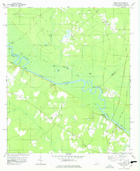
1978 Map of Brighton
USGS Topo · Published 1978About this map
The Savannah River winds through a dense landscape of oxbow lakes and wetlands along the border of South Carolina and Georgia. This late 1970s survey captures the river's complex hydrologic character, defined by numerous named features such as Fowl Craw Lake, Loggy Lake, and Boggy Bluff Lake. The settlement of Brighton sits inland, connected to the riverine economy by historical access points like Porters Landing, Stokes Bluff Landing, and Tuckasee King Landing.
Find a feature on this map
35 named features on this map. Tap any name to fly to it.
Don’t see what you’re looking for? This feature index may not catch every label — zoom into the map to look around manually.
Map Details
Editions of this 1978 Brighton Map
This is the sole edition of this map. No revisions or reprints were ever made.
Other maps of this area

1919 · Pineland
USGS Topo · 1:62,500

1919 · Shirley
USGS Topo · 1:62,500

1919 · Egypt
USGS Topo · 1:62,500

1920 · Hardeeville
USGS Topo · 1:62,500

1939 · Egypt
USGS Topo · 1:62,500

1943 · Pineland
USGS Topo · 1:62,500

1943 · Hardeeville
USGS Topo · 1:62,500

1943 · Egypt
USGS Topo · 1:62,500

1943 · Shirley
USGS Topo · 1:62,500

1947 · Savannah
USGS Topo · 1:250,000