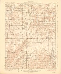
1928 Map of Brighton
USGS Topo · Published 1928About this map
Macoupin Creek meanders across the northern reaches of this rural landscape, marking a transition between the more dissected creek bottoms and the level prairie uplands of southwestern Illinois. During the mid-1920s, this region was defined by a dense network of one-room schools and small farming hubs tied together by three major rail lines. The Chicago and Alton and the Chicago Burlington and Quincy railroads intersect at Brighton, while the Chicago Peoria and St Louis serves the western edge through Medora and Fidelity. Genealogists will find a wealth of local landmarks, including over twenty named schools such as Brush College School and Washington School, alongside rural meeting places like Bethel Church and Paradise Church. The map captures the agricultural economy just as early aerial photography, conducted by the Army Air Corps, began to modernize topographical surveying in Macoupin and Jersey counties.
Find a feature on this map
65 named features on this map. Tap any name to fly to it.
Don’t see what you’re looking for? This feature index may not catch every label — zoom into the map to look around manually.
Map Details
Editions of this 1928 Brighton Map
2 editions found

Other maps of this area

1912 · Gillespie
USGS Topo · 1:62,500

1915 · Gillespie
USGS Topo · 1:62,500

1923 · Carlinville
USGS Topo · 1:48,000

1924 · Roodhouse
USGS Topo · 1:62,500

1925 · Carlinville
USGS Topo · 1:62,500

1925 · Brighton
USGS Topo · 1:62,500

1926 · Roodhouse
USGS Topo · 1:62,500

1927 · Alton
USGS Topo · 1:62,500

1927 · St. Charles
USGS Topo · 1:62,500

1927 · Edwardsville
USGS Topo · 1:62,500