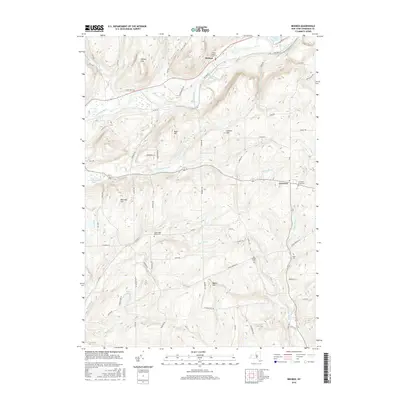
2016 Map of Brisben
USGS Topo · Published 2016About this map
The Chenango River valley and its surrounding highlands define this portion of Chenango County, showing a landscape shaped by both water and agriculture. The settlement of Brisben sits near the river's edge, anchored by the Brisben Baptist Church and a rail line that traces the valley floor. To the southeast, the village of Coventry occupies higher ground near the headwaters of Wylie Brook. This terrain is notable for its numerous burial grounds, including the Upper Page Brook Cem and Old Chapel Cem, which offer significant value for genealogical research. The topography is marked by several prominent summits like Harbor Hill and Bobell Hill, separated by drainages such as Page Brook and Wheeler Brook. The road network, including Co RD 32 and Co RD 9, connects isolated farmsteads across the undulating hills of central New York.
Find a feature on this map
70 named features on this map. Tap any name to fly to it.
Don’t see what you’re looking for? This feature index may not catch every label — zoom into the map to look around manually.
Map Details
Editions of this 2016 Brisben Map
This is the sole edition of this map. No revisions or reprints were ever made.
Other maps of this area

1902 · Coventry
USGS Topo · 1:62,500

1904 · Binghamton
USGS Topo · 1:62,500

1904 · Greene
USGS Topo · 1:62,500

1904 · Oxford
USGS Topo · 1:62,500

1905 · Nineveh
USGS Topo · 1:62,500

1935 · Chenango Forks
USGS Topo · 1:24,000

1942 · Chenango Forks
USGS Topo · 1:31,680
1948 · Greene
USGS Topo · 1:24,000
1948 · Smithville Flats
USGS Topo · 1:24,000

1948 · Binghamton
USGS Topo · 1:250,000