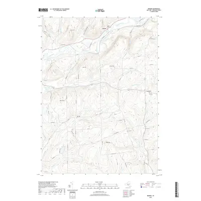
2019 Map of Brisben
USGS Topo · Published 2019About this map
The Chenango River valley defines the northwestern reaches of this rural Chenango County landscape, where the small settlement of Brisben sits along the historical corridor of Railroad St. To the southeast, the village of Coventry serves as another focal point for the surrounding highlands. The area is marked by numerous family-named hills and hollows, such as Harbor Hill, Buck Hill, and Cohoon Hill, interspersed with small water bodies like Van Valkenburgh Pond. Genealogists will find a wealth of burial sites throughout the township, ranging from the Brisben Baptist Church-Cem to more remote locations like Upper Page Brook Cem and Chapel Cem. The drainage patterns of Page Brook and Wylie Brook illustrate the complex topography of the region, which is tied together by a network of local roads such as Coultermarsh Rd and Hattie Clark Rd.
Find a feature on this map
67 named features on this map. Tap any name to fly to it.
Don’t see what you’re looking for? This feature index may not catch every label — zoom into the map to look around manually.
Map Details
Editions of this 2019 Brisben Map
This is the sole edition of this map. No revisions or reprints were ever made.
Other maps of this area

1902 · Coventry
USGS Topo · 1:62,500

1904 · Binghamton
USGS Topo · 1:62,500

1904 · Greene
USGS Topo · 1:62,500

1904 · Oxford
USGS Topo · 1:62,500

1905 · Nineveh
USGS Topo · 1:62,500

1935 · Chenango Forks
USGS Topo · 1:24,000

1942 · Chenango Forks
USGS Topo · 1:31,680
1948 · Greene
USGS Topo · 1:24,000
1948 · Smithville Flats
USGS Topo · 1:24,000

1948 · Binghamton
USGS Topo · 1:250,000