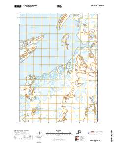
2019 Map of Bristol Bay B-1 SE
USGS Topo · Published 2019About this map
Bristol Bay dominates the northwestern portion of this coastal survey, where the tidewaters of the Bering Sea meet the complex wetlands of the Alaska Peninsula. The landscape is defined by the Cinder River, which meanders through a labyrinth of smaller channels and interconnected coastal ponds. This area is characterized by low-lying maritime terrain, where the shifting hydrology of the river mouth creates a dynamic interface between the open bay and the interior marshlands. The lack of infrastructure or established roads on this 2019 survey emphasizes the area's role as a biological and geographic corridor rather than a site of permanent settlement. For researchers of the Lake and Peninsula Borough, this map provides a detailed record of the hydrography near the Bristol Bay shoreline, showing the intricate drainage patterns that define the region's coastal morphology.
Find a feature on this map
7 named features on this map. Tap any name to fly to it.
Don’t see what you’re looking for? This feature index may not catch every label — zoom into the map to look around manually.
Map Details
Editions of this 2019 Bristol Bay B-1 SE Map
This is the sole edition of this map. No revisions or reprints were ever made.
Other maps of this area

1943 · Ugashik
USGS Topo · 1:250,000

1948 · Ugashik
USGS Topo · 1:250,000

1949 · Ugashik
USGS Topo · 1:250,000

1951 · Bristol Bay
USGS Topo · 1:250,000

1963 · Ugashik B-6
USGS Topo · 1:63,360

1963 · Ugashik A-6
USGS Topo · 1:63,360

1963 · Bristol Bay
USGS Topo · 1:250,000

1963 · Bristol Bay A-1
USGS Topo · 1:63,360
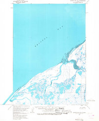
1963 · Bristol Bay B-1
USGS Topo · 1:63,360

1963 · Ugashik
USGS Topo · 1:250,000