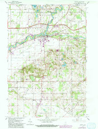
1961 Map of Bristol
USGS Topo · Published 1982About this map
The St Joseph River meanders through northern Elkhart County, anchoring the town of Bristol and the nearby settlement of Nibbyville. This early 1960s landscape, later updated in the early 1980s, reveals a mix of agricultural heritage and modern transportation infrastructure, with the Indiana Toll Road and the Central New York railroad corridor cutting across the northern half of the map.
Find a feature on this map
46 named features on this map. Tap any name to fly to it.
Don’t see what you’re looking for? This feature index may not catch every label — zoom into the map to look around manually.
Map Details
Editions of this 1961 Bristol Map
4 editions found
Other maps of this area

1914 · Three Rivers
USGS Topo · 1:62,500

1916 · Three Rivers
USGS Topo · 1:62,500

1943 · Three Rivers
USGS Topo · 1:62,500

1948 · Vandalia
USGS Topo · 1:62,500

1949 · Vandalia
USGS Topo · 1:62,500

1953 · Fort Wayne
USGS Topo · 1:250,000

1956 · Fort Wayne
USGS Topo · 1:250,000

1959 · Millersburg
USGS Topo · 1:24,000

1959 · Goshen
USGS Topo · 1:24,000

1960 · Foraker
USGS Topo · 1:24,000