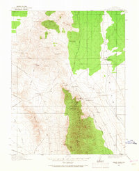
1915 Map of Bristol Range
USGS Topo · Published 1968About this map
Bristol Mines and the Jackrabbit Mine anchor the industrial landscape of the Bristol Range during this 1915 survey of Lincoln County. The map details a high-desert mining economy dependent on a network of remote water sources such as Fifteenmile Well, Bailey Spring, and the dry station at Twentyone Mile Well. Transportation in the region was defined by the Pioche and Pacific Narrow Gage Road, which navigated the difficult terrain between Bristol Pass and the eastern flats of Patterson Wash. Sparse settlements like Bristol Well and Stonehouse provided essential hubs for prospectors and teamsters traveling the Sunnyside Road or the Cherry Creek and Pioche Road. From the heights of Fairview Pk to the low expanse of Dry Lake Valley, the sheet captures the infrastructure of a Great Basin mining district before the era of modern highways.
Find a feature on this map
44 named features on this map. Tap any name to fly to it.
Don’t see what you’re looking for? This feature index may not catch every label — zoom into the map to look around manually.
Map Details
Editions of this 1915 Bristol Range Map
2 editions found
Other maps of this area

1885 · Pioche
USGS Topo · 1:250,000

1886 · Pioche
USGS Topo · 1:250,000

1915 · Bristol Range
USGS Topo · 1:62,500

1916 · Highland
USGS Topo · 1:62,500

1917 · Bristol Range
USGS Topo · 1:62,500

1918 · Highland
USGS Topo · 1:62,500

1921 · NW 1/4 Panaca
USGS Topo · 1:48,000

1953 · Highland Peak
USGS Topo · 1:24,000

1953 · Bristol Range SE
USGS Topo · 1:24,000

1953 · Pioche
USGS Topo · 1:24,000