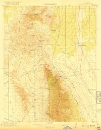
1917 Map of Bristol Range
USGS Topo · Published 1917About this map
The Bristol Range and the neighboring Ely Range dominate this Lincoln County landscape during a period of significant mining activity. Hard-rock operations like the Jackrabbit Mine, Bristol Mines, and Lucky Star Mine are connected to the broader world by the Pioche Pacific (Narrow Gage) railroad, which winds through the mountain passes. The map reveals the critical importance of water in this arid environment, documenting a network of isolated springs and wells such as Wildhorse Bill Spring, Fifteenmile Well, and Bristol Well that supported both industrial operations and the small settlements at Jackrabbit and Stonehouse. The terrain transitions from the high peaks of Fairview Pk down to the broad, flat expanse of Lake Valley and the seasonal drainage of Patterson Wash, illustrating the logistical challenges faced by early 20th-century miners and freighters traveling the Sunnyside Road and Pioche Road.
Find a feature on this map
35 named features on this map. Tap any name to fly to it.
Don’t see what you’re looking for? This feature index may not catch every label — zoom into the map to look around manually.
Map Details
Editions of this 1917 Bristol Range Map
2 editions found
Other maps of this area

1885 · Pioche
USGS Topo · 1:250,000

1886 · Pioche
USGS Topo · 1:250,000

1915 · Bristol Range
USGS Topo · 1:62,500

1916 · Highland
USGS Topo · 1:62,500

1917 · Bristol Range
USGS Topo · 1:62,500

1918 · Highland
USGS Topo · 1:62,500

1921 · NW 1/4 Panaca
USGS Topo · 1:48,000

1953 · Highland Peak
USGS Topo · 1:24,000

1953 · Bristol Range SE
USGS Topo · 1:24,000

1953 · Pioche
USGS Topo · 1:24,000