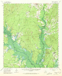
1958 Map of Broaddus
USGS Topo · Published 1972About this map
Suttons Mill and the surrounding piney woods of East Texas are documented here during a pivotal era of the mid-20th century. This territory, largely defined by the Angelina National Forest, shows a landscape organized around the Angelina River and its numerous tributaries like Attoyac Bayou. Small, dispersed settlements such as Etoile, Broaddus, and New Camp serve as the primary nodes of activity, connected by a network of unimproved roads and an Old Railroad grade that speaks to the region's logging history.
Find a feature on this map
91 named features on this map. Tap any name to fly to it.
Don’t see what you’re looking for? This feature index may not catch every label — zoom into the map to look around manually.
Map Details
Editions of this 1958 Broaddus Map
3 editions found

Other maps of this area

1931 · Zavalla
USGS Topo · 1:62,500

1932 · Manning
USGS Topo · 1:62,500

1949 · Lufkin
USGS Topo · 1:62,500

1949 · Platt
USGS Topo · 1:24,000

1949 · Huntington
USGS Topo · 1:24,000

1950 · Platt
USGS Topo · 1:24,000

1950 · Huntington
USGS Topo · 1:24,000

1952 · Nacogdoches
USGS Topo · 1:62,500

1953 · Palestine
USGS Topo · 1:250,000

1957 · Palestine
USGS Topo · 1:250,000