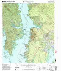
2003 Map of Broaddus
USGS Topo · Published 2004About this map
Angelina National Forest dominates this East Texas landscape, where the waters of the Sam Rayburn Reservoir reach into the timberlands of San Augustine and Nacogdoches counties. The settlement of Broaddus sits on the eastern edge of the forest, serving as a gateway to the extensive recreational shoreline. The map documents a geography heavily shaped by the impoundment of the Angelina River, showing numerous boat ramps and parks like Shirley Creek Park (COE) and Townsend Recreation Area (COE). For genealogists, the map preserves the locations of several rural burial grounds tucked into the forest and hills, including Lowery Cem, Smyrna Cem, and St Peter Cem near St Peter Ch. The presence of the Jackson Hill Lookout and a network of forest roads highlights the ongoing management of these piney woods decades after the reservoir's creation.
Find a feature on this map
21 named features on this map. Tap any name to fly to it.
Don’t see what you’re looking for? This feature index may not catch every label — zoom into the map to look around manually.
Map Details
Editions of this 2003 Broaddus Map
This is the sole edition of this map. No revisions or reprints were ever made.
Other maps of this area

1931 · Zavalla
USGS Topo · 1:62,500

1953 · Palestine
USGS Topo · 1:250,000

1957 · Palestine
USGS Topo · 1:250,000

1958 · Zavalla
USGS Topo · 1:62,500

1958 · Broaddus
USGS Topo · 1:62,500

1958 · Mc Gee Bend
USGS Topo · 1:62,500

1958 · Bronson
USGS Topo · 1:62,500

1984 · Norwood
USGS Topo · 1:24,000
1984 · Veach
USGS Topo · 1:24,000
1984 · Etoile North
USGS Topo · 1:24,000