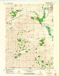
1962 Map of Brodhead West
USGS Topo · Published 1964About this map
The Sugar River meanders through the eastern portion of this landscape, defining the industrial and civic heart of Brodhead. Along its banks, early 1960s infrastructure is visible, including a powerplant, Sewage Disposal plant, and a Gaging Station. The Chicago Milwaukee St Paul and Pacific railroad bisects the terrain, connecting the larger settlement of Brodhead with the smaller village of Juda to the west. This rail line served as a vital artery for the agricultural economy, evidenced by the numerous gravel pits and a Quarry scattered near the tracks.
Find a feature on this map
34 named features on this map. Tap any name to fly to it.
Don’t see what you’re looking for? This feature index may not catch every label — zoom into the map to look around manually.
Map Details
Editions of this 1962 Brodhead West Map
3 editions found
Other maps of this area

1893 · Brodhead
USGS Topo · 1:62,500

1920 · Monroe
USGS Topo · 1:62,500

1922 · Monroe
USGS Topo · 1:62,500

1932 · Pecatonica
USGS Topo · 1:62,500

1936 · Pecatonica
USGS Topo · 1:62,500

1939 · Freeport
USGS Topo · 1:48,000

1944 · Freeport
USGS Topo · 1:62,500

1954 · Rockford
USGS Topo · 1:250,000

1955 · Rockford
USGS Topo · 1:250,000

1958 · Rockford
USGS Topo · 1:250,000