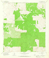
1963 Map of Brokeleg Mountain
USGS Topo · Published 1966About this map
Brokeleg Mountain anchors this 1963 survey of the Sutton County landscape, a terrain defined by the deep incisions of Cat Hollow and Bell Hollow. The map reveals a ranching economy organized around water sources and subtle changes in elevation, with numerous family-held holdings such as the Schwiening Ranch and Wyatt Ranch dispersed throughout the territory. Drainage patterns are clearly marked by the winding paths of Epps Creek and West Copperas Creek, which dictate the placement of roads and homesteads. The presence of multiple Gravel Pits and a prominent Pipeline corridor suggests the intersection of traditional land use with mid-century industrial development. Local historians can trace the specific boundaries of late 20th-century ranching life, from Peach Springs to the Kelley Ranch, during a period when these family names were central to the regional identity.
Find a feature on this map
19 named features on this map. Tap any name to fly to it.
Don’t see what you’re looking for? This feature index may not catch every label — zoom into the map to look around manually.
Map Details
Editions of this 1963 Brokeleg Mountain Map
2 editions found
Other maps of this area

1893 · Rock Springs
USGS Topo · 1:125,000

1893 · Fort McKavett
USGS Topo · 1:125,000

1954 · Sonora
USGS Topo · 1:250,000

1958 · Sonora
USGS Topo · 1:250,000

1962 · Roosevelt
USGS Topo · 1:24,000

1963 · Buffalo Well
USGS Topo · 1:24,000

1963 · Live Oak Draw
USGS Topo · 1:24,000

1963 · McKegan Draw
USGS Topo · 1:24,000

1963 · Buffalo Well SE
USGS Topo · 1:24,000
1963 · Fort Terrett Ranch
USGS Topo · 1:24,000