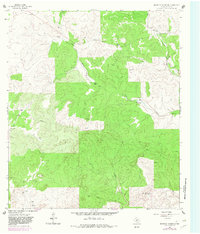
1963 Map of Brokeleg Mountain
USGS Topo · Published 1982About this map
Brokeleg Mountain rises above a landscape defined by cattle ranching and deep limestone drainages in Sutton County. This 1960s topographical study, updated in the early 1980s, reveals a network of family ranching operations including the Schwiening Ranch, Jacoby Ranch, and Wyatt Ranch. The distribution of these ranch headquarters suggests a settlement pattern tied to the limited water resources of the Edwards Plateau, where seasonal drainages like Epps Creek and West Copperas Creek provide the primary geographic structure. Scattered Gravel Pits indicate local material extraction, while a prominent Pipeline corridor cuts across the southern portion of the quadrangle. The map is a specific record of the remote Texas Hill Country before further modernization, documenting old fence lines and isolated outposts such as the L Luckie Ranch and the N Gibbs Ranch.
Find a feature on this map
20 named features on this map. Tap any name to fly to it.
Don’t see what you’re looking for? This feature index may not catch every label — zoom into the map to look around manually.
Map Details
Editions of this 1963 Brokeleg Mountain Map
2 editions found
Other maps of this area

1893 · Rock Springs
USGS Topo · 1:125,000

1893 · Fort McKavett
USGS Topo · 1:125,000

1954 · Sonora
USGS Topo · 1:250,000

1958 · Sonora
USGS Topo · 1:250,000

1962 · Roosevelt
USGS Topo · 1:24,000

1963 · Buffalo Well
USGS Topo · 1:24,000

1963 · Live Oak Draw
USGS Topo · 1:24,000

1963 · McKegan Draw
USGS Topo · 1:24,000

1963 · Buffalo Well SE
USGS Topo · 1:24,000
1963 · Fort Terrett Ranch
USGS Topo · 1:24,000