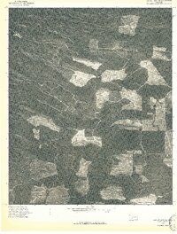
1976 Map of Broken bow NE
USGS Topo · Published 1976About this map
Welch Mountain and West Fork Mountain dominate the terrain in this portion of McCurtain County, as seen through high-altitude aerial imagery captured in the fall of 1976. This orthophotoquad provides a stark visual record of timber management and forest density in the Oklahoma hills, showing the intricate network of logging roads and clearings that cross the slopes. Unlike a standard topographic line drawing, this survey uses a rectified photograph to show the actual texture of the woods and the specific geometry of land use. The contrast between the dark, dense stands of timber and the bright, cleared patches illustrates the industrial forestry patterns prevalent in the region during the mid-1970s.
Find a feature on this map
2 named features on this map. Tap any name to fly to it.
Don’t see what you’re looking for? This feature index may not catch every label — zoom into the map to look around manually.
Map Details
Editions of this 1976 Broken bow NE Map
This is the sole edition of this map. No revisions or reprints were ever made.
Other maps of this area

1902 · Lukfata
USGS Topo · 1:125,000

1913 · De Queen
USGS Topo · 1:125,000

1950 · Mcalester
USGS Topo · 1:250,000

1959 · Cove
USGS Topo · 1:62,500

1959 · Broken Bow
USGS Topo · 1:62,500

1960 · Smithville
USGS Topo · 1:62,500

1962 · McAlester
USGS Topo · 1:250,000

1965 · McAlester
USGS Topo · 1:250,000
1965 · Chapel Hill
USGS Topo · 1:24,000
1966 · De Queen NW
USGS Topo · 1:24,000