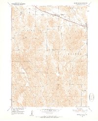
1951 Map of Broken Bow SE
USGS Topo · Published 1952About this map
Berwyn stands as the primary rail settlement in this 1951 snapshot of Custer County, situated along the Chicago Burlington and Quincy railroad line. The landscape is defined by the drainage systems of Mud Creek and Deer Creek, which cut through the agricultural plateaus of Broken Bow and Berwyn townships. The map reveals a dense network of rural infrastructure typical of mid-century Nebraska, notably the preservation of local school districts.
Find a feature on this map
17 named features on this map. Tap any name to fly to it.
Don’t see what you’re looking for? This feature index may not catch every label — zoom into the map to look around manually.
Map Details
Editions of this 1951 Broken Bow SE Map
3 editions found
Other maps of this area

1951 · Broken Bow NE
USGS Topo · 1:24,000

1951 · Westerville
USGS Topo · 1:24,000

1951 · Broken Bow SW
USGS Topo · 1:24,000

1951 · Ansley
USGS Topo · 1:24,000

1951 · Broken Bow
USGS Topo · 1:24,000

1951 · Broken Bow SE
USGS Topo · 1:24,000

1951 · Eddyville NE
USGS Topo · 1:24,000

1951 · Eddyville NW
USGS Topo · 1:24,000

1951 · Mason City NW
USGS Topo · 1:24,000

1955 · Broken Bow
USGS Topo · 1:250,000