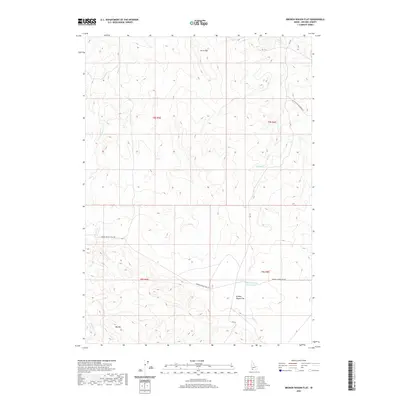
2020 Map of Broken Wagon Flat
USGS Topo · Published 2020About this map
Broken Wagon Flat serves as the focal point of this high-desert landscape in southwestern Idaho, where the topography is defined by significant elevations like Horse Hill and Big Hill. The name itself hints at the area's history of transit and cattle ranching, a legacy reinforced by the network of remote thoroughfares such as Broken Wagon Trail Rd and Broken Wagon Flat Rd. Water management is central to life in this arid region, evidenced by the Broken Wagon Flat Reservoir and intermittent drainages like Sugar Cr and Hot Cr. The presence of the CCC Rd suggests a landscape shaped by mid-20th-century conservation and infrastructure projects. This survey provides a clear view of the rangeland divisions between T8S and T9S, illustrating the enduring survey grid and road systems that continue to facilitate movement across this corner of Owyhee County.
Find a feature on this map
15 named features on this map. Tap any name to fly to it.
Don’t see what you’re looking for? This feature index may not catch every label — zoom into the map to look around manually.
Map Details
Editions of this 2020 Broken Wagon Flat Map
This is the sole edition of this map. No revisions or reprints were ever made.
Other maps of this area

1947 · Little Valley
USGS Topo · 1:24,000

1947 · Bruneau
USGS Topo · 1:62,500

1947 · Sugar Valley
USGS Topo · 1:24,000

1947 · Hot Spring
USGS Topo · 1:24,000
1948 · Little Valley
USGS Topo · 1:24,000

1948 · Sugar Valley
USGS Topo · 1:24,000

1948 · Indian Cove
USGS Topo · 1:62,500
1949 · Hot Spring
USGS Topo · 1:24,000

1955 · Twin Falls
USGS Topo · 1:250,000

1956 · Big Hill
USGS Topo · 1:62,500