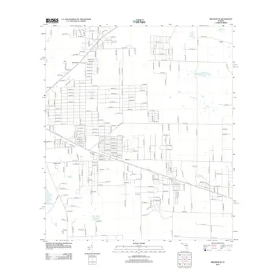
2012 Map of Bronson NE
USGS Topo · Published 2012About this map
Spring Hill and Merediths anchor a landscape defined by an extensive grid of local roads and natural depressions in Levy County. This part of Florida is characterized by its numerous water features, from the large Sawgrass Lake in the east to more localized basins like German Pond and Marshall Pond. The presence of Cherry Sink suggests the underlying limestone geology common to the region, where surface water often drains into subterranean systems. In the southern reach of the survey, the Smith Cem serves as a significant landmark for those tracing local family history and rural development. The settlement of Adam appears in the northeast, connected to the broader region by a network of numbered avenues and streets that contrast with the irregular boundaries of the surrounding wetlands and ponds like Chunky Pond and Sand Pond.
Find a feature on this map
119 named features on this map. Tap any name to fly to it.
Don’t see what you’re looking for? This feature index may not catch every label — zoom into the map to look around manually.
Map Details
Editions of this 2012 Bronson NE Map
This is the sole edition of this map. No revisions or reprints were ever made.
Other maps of this area

1890 · Arredondo
USGS Topo · 1:62,500

1892 · Arredondo
USGS Topo · 1:62,500

1894 · Arredondo
USGS Topo · 1:62,500

1895 · Williston
USGS Topo · 1:62,500

1954 · Bronson
USGS Topo · 1:24,000

1954 · Bronson SW
USGS Topo · 1:24,000

1954 · Gainesville
USGS Topo · 1:250,000

1955 · Bronson NE
USGS Topo · 1:24,000

1955 · Bronson SE
USGS Topo · 1:24,000
1957 · Bronson SE
USGS Topo · 1:25,000