
1957 Map of Brookeland
USGS Topo · Published 1959About this map
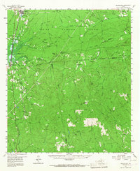
The Sabine National Forest dominates this landscape in the late 1950s, where the convergence of Sabine, Jasper, and Newton counties meets a dense network of creek drainages. Major timber and rail hubs like Pineland and Brookeland anchor the northern and western margins, connected by the Gulf Colorado and Santa Fe Railway. Away from the main lines, the forest is dotted with small family and community centers such as Weeks Settlement, Scrapping Valley, and Browndell. Of particular note for local history is the Low Cem (Historical Mon), alongside numerous country churches including Lone Star Ch and Spring Hill Ch. The mapping of an Old Railroad Grade and several Jeep Trails indicates the changing nature of forest access and the legacy of earlier logging operations that preceded the modern forest boundaries.
Find a feature on this map
78 named features on this map. Tap any name to fly to it.
Don’t see what you’re looking for? This feature index may not catch every label — zoom into the map to look around manually.
Map Details
Editions of this 1957 Brookeland Map
2 editions found
Other maps of this area

1944 · Negreet
USGS Topo · 1:62,500

1944 · Wiergate
USGS Topo · 1:62,500

1948 · Wiergate
USGS Topo · 1:62,500

1952 · Lake Charles
USGS Topo · 1:250,000

1953 · Alexandria
USGS Topo · 1:250,000

1953 · Palestine
USGS Topo · 1:250,000

1954 · Wiergate
USGS Topo · 1:24,000

1954 · Columbus
USGS Topo · 1:24,000

1954 · Fairdale
USGS Topo · 1:24,000

1954 · Negreet
USGS Topo · 1:62,500