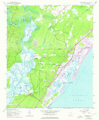
1943 Map of Brookgreen
USGS Topo · Published 1976About this map
The Waccamaw River divides this coastal landscape, separating the dense network of swamps and rice-field channels on Sandy Island from the emerging coastal developments of the mid-20th century. On the western bank, river landings like Wachesaw Landing and Mulberry Landing hint at an era of river-borne commerce and historic plantation sites. The eastern side of the quadrangle shows the transformation of the Grand Strand, where the established community of Murrells Inlet sits adjacent to newer shoreline features like Garden City Beach and several trailer parks. Grounded in the southern portion of the map is Brookgreen Gardens, a notable cultural landmark established on former plantation lands. Between the river and the sea, a patchwork of community life is visible through local institutions such as Bethel Ch, Gordons Ch, and the Wildwood Sch, illustrating the transition from rural agricultural clusters to a modern maritime and recreational economy.
Find a feature on this map
60 named features on this map. Tap any name to fly to it.
Don’t see what you’re looking for? This feature index may not catch every label — zoom into the map to look around manually.
Map Details
Editions of this 1943 Brookgreen Map
5 editions found
Other maps of this area

1937 · Myrtle Beach
USGS Topo · 1:48,000

1940 · Myrtle Beach
USGS Topo · 1:62,500

1942 · Magnolia Beach
USGS Topo · 1:24,000

1942 · Waverly Mills
USGS Topo · 1:24,000

1943 · Yauhannah
USGS Topo · 1:24,000

1943 · Bucksville
USGS Topo · 1:24,000

1943 · Brookgreen
USGS Topo · 1:24,000

1943 · Plantersville
USGS Topo · 1:24,000

1949 · Georgetown
USGS Topo · 1:250,000

1967 · Georgetown
USGS Topo · 1:250,000
Featured Places
- Garden City Beach, SC
- Murrells Inlet, SC
- Sunny Side, Murrells Inlet
- Prince Creek West, SC
- International Club, SC