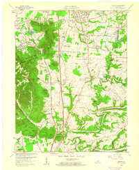
1959 Map of Brooks
USGS Topo · Published 1960About this map
South Park Hills and a series of prominent knobs define the topography between the Jefferson and Bullitt county line at the close of the 1950s. The landscape is characterized by the intersection of traditional rural settlements like Zoneton and Brooks with the modern infrastructure of the Kentucky Turnpike and the Louisville and Nashville railroad. Communities are anchored by local institutions such as Hebron Ch, Little Flock Ch, and Brooks Sch, while family history is etched into the land at McCawley Cem and Terry Cem. Along the winding path of Floyds Fork and the Salt River, the map reveals a transition from wooded ridges to river bottomlands. This survey documents the area's mid-century character, from the Holsclaw Lookout Tower in the Jefferson County Memorial Forest to the industrial presence of a quarry and Kenlite Sta.
Find a feature on this map
79 named features on this map. Tap any name to fly to it.
Don’t see what you’re looking for? This feature index may not catch every label — zoom into the map to look around manually.
Map Details
Editions of this 1959 Brooks Map
2 editions found
Other maps of this area

1907 · Louisville
USGS Topo · 1:62,500

1909 · Kosmosdale
USGS Topo · 1:48,000

1912 · Kosmosdale
USGS Topo · 1:62,500

1936 · Vine Grove
USGS Topo · 1:62,500

1943 · Vine Grove
USGS Topo · 1:62,500

1946 · Pitts Point
USGS Topo · 1:24,000

1946 · Vine Grove
USGS Topo · 1:62,500

1949 · Shepherdsville
USGS Topo · 1:24,000

1949 · Samuels
USGS Topo · 1:24,000

1949 · Shepherdsville
USGS Topo · 1:62,500