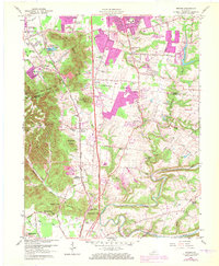
1959 Map of Brooks
USGS Topo · Published 1972About this map
South Park Hills and a series of prominent knobs define the terrain along the Jefferson and Bullitt county line. During this mid-century period, the landscape transitioned from the wooded heights of Buttonmold Knob and Wagonbed Knob to the expanding residential outskirts of Minor Lane Heights and South Park View. The Louisville and Nashville RR serves as a primary industrial spine, running parallel to the Preston Highway, where the local economy appears rooted in transport and extraction, evidenced by several quarries, a conveyor, and brick kilns.
Find a feature on this map
95 named features on this map. Tap any name to fly to it.
Don’t see what you’re looking for? This feature index may not catch every label — zoom into the map to look around manually.
Map Details
Editions of this 1959 Brooks Map
2 editions found
Other maps of this area

1907 · Louisville
USGS Topo · 1:62,500

1909 · Kosmosdale
USGS Topo · 1:48,000

1912 · Kosmosdale
USGS Topo · 1:62,500

1936 · Vine Grove
USGS Topo · 1:62,500

1943 · Vine Grove
USGS Topo · 1:62,500

1946 · Pitts Point
USGS Topo · 1:24,000

1946 · Vine Grove
USGS Topo · 1:62,500

1949 · Shepherdsville
USGS Topo · 1:24,000

1949 · Samuels
USGS Topo · 1:24,000

1949 · Shepherdsville
USGS Topo · 1:62,500