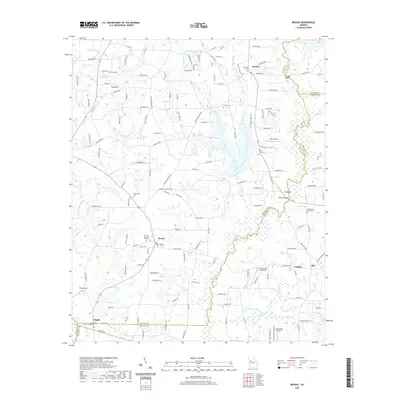
2020 Map of Brooks
USGS Topo · Published 2020About this map
Brooks serves as a focal point in this southern Fayette County landscape, where the town layout is defined by the intersection of Gage Rd and W McIntosh Rd. The area maintains a rural character dominated by family heritage and aviation, evidenced by the numerous burial grounds like John Bates Family Cem and Brooks City Cem. The drainage patterns of the Flint River, which serves as a county boundary, and its tributaries like Whitewater Creek and Horton Cr, have historically influenced the placement of crossings such as Reaves Bridge.
Find a feature on this map
151 named features on this map. Tap any name to fly to it.
Don’t see what you’re looking for? This feature index may not catch every label — zoom into the map to look around manually.
Map Details
Editions of this 2020 Brooks Map
This is the sole edition of this map. No revisions or reprints were ever made.
Other maps of this area

1953 · Atlanta
USGS Topo · 1:250,000

1957 · Atlanta
USGS Topo · 1:250,000

1958 · Atlanta
USGS Topo · 1:250,000

1965 · Tyrone
USGS Topo · 1:24,000
1965 · Hampton
USGS Topo · 1:24,000

1965 · Fayetteville
USGS Topo · 1:24,000

1965 · Senoia
USGS Topo · 1:24,000

1965 · Griffin North
USGS Topo · 1:24,000

1965 · Brooks
USGS Topo · 1:24,000

1971 · Hollonville
USGS Topo · 1:24,000