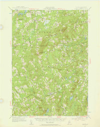
1955 Map of Brooks
USGS Topo · Published 1957About this map
Lake Passagassawakeag and the surrounding mid-century landscape of Waldo County are defined by a network of small upland hamlets and rural schoolhouses. This 1955 revision of earlier surveys reveals a patchwork of local centers such as Nickerson Mills, Rollins Mills, and Town House Corners, many linked by an extensive system of jeep trails and secondary roads. Significant landmarks for local history include the Mount Harris Lookout Tower and the Peaked Mtn Airway Beacon, reflecting the era's reliance on high-ground infrastructure for fire spotting and aerial navigation.
Find a feature on this map
128 named features on this map. Tap any name to fly to it.
Don’t see what you’re looking for? This feature index may not catch every label — zoom into the map to look around manually.
Map Details
Editions of this 1955 Brooks Map
4 editions found

Other maps of this area

1900 · Bucksport
USGS Topo · 1:62,500

1902 · Bucksport
USGS Topo · 1:62,500

1902 · Bangor
USGS Topo · 1:62,500

1902 · Castine
USGS Topo · 1:62,500

1904 · Castine
USGS Topo · 1:62,500

1905 · Penobscot Bay
USGS Topo · 1:125,000

1915 · Belfast
USGS Topo · 1:62,500

1916 · Liberty
USGS Topo · 1:62,500

1917 · Belfast
USGS Topo · 1:62,500

1926 · Burnham
USGS Topo · 1:62,500