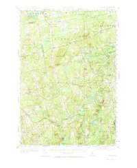
1955 Map of Brooks
USGS Topo · Published 1974About this map
Brooks serves as a primary hub within this mid-century depiction of Waldo and Penobscot counties, where the Belfast and Moosehead Lake railroad line winds through the southern landscape near Knox Sta. The area is characterized by an intricate network of small hamlets and crossroads such as Jackson Corners, Dixmont Center, and Simpson Corners, reflecting a deeply established rural settlement pattern. Industrial history is evident at Rollins Mills and Nickerson Mills, while the presence of the Peaked Mtn Airway Beacon and Mount Harris Lookout Tower highlights the era's navigational and fire-watch infrastructure. Numerous family-named cemeteries, including Knowlton Cem and Styles Cem, are scattered among the ridges of Robertson Mtn and Goodwin Hill, offering vital data points for genealogists researching the residents of Thorndike and Monroe.
Find a feature on this map
126 named features on this map. Tap any name to fly to it.
Don’t see what you’re looking for? This feature index may not catch every label — zoom into the map to look around manually.
Map Details
Editions of this 1955 Brooks Map
4 editions found

Other maps of this area

1900 · Bucksport
USGS Topo · 1:62,500

1902 · Bucksport
USGS Topo · 1:62,500

1902 · Bangor
USGS Topo · 1:62,500

1902 · Castine
USGS Topo · 1:62,500

1904 · Castine
USGS Topo · 1:62,500

1905 · Penobscot Bay
USGS Topo · 1:125,000

1915 · Belfast
USGS Topo · 1:62,500

1916 · Liberty
USGS Topo · 1:62,500

1917 · Belfast
USGS Topo · 1:62,500

1926 · Burnham
USGS Topo · 1:62,500