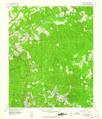
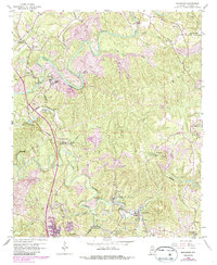
1959 Map of Brookside
USGS Topo · Published 1960About this map
The winding loops of Locust Fork and Fivemile Creek define this section of the Birmingham Coal District during the late 1950s. The landscape is a complex intersection of heavy industry and small communities, with numerous Strip Mine operations and Strip Mines appearing alongside established settlements like Brookside and Graysville. Transportation networks are densely packed, featuring the Bankhead Highway and multiple rail lines, including the Southern Railway and the Louisville And Nashville Railroad, which served the region's mining interests. Local heritage is deeply rooted in the many small churches and schools that dot the hills, such as Caledonia Ch and Old Caledonia Ch in the northeast, and St Pauls Ch near Pinkney City. The presence of the U S Reservation (Flat Top Experimental Forest) provides a distinct contrast to the industrial activity that otherwise dominates the river valleys.
Find a feature on this map
44 named features on this map. Tap any name to fly to it.
Don’t see what you’re looking for? This feature index may not catch every label — zoom into the map to look around manually.
Map Details
Editions of this 1959 Brookside Map
5 editions found
Other maps of this area

1889 · Birmingham
USGS Topo · 1:125,000

1892 · Birmingham
USGS Topo · 1:125,000

1893 · Jasper
USGS Topo · 1:125,000

1895 · Birmingham
USGS Topo · 1:125,000

1904 · Birmingham Coal District
USGS Topo · 1:62,500

1906 · Birmingham Special
USGS Topo · 1:62,500

1907 · Birmingham
USGS Topo · 1:125,000

1935 · Port Birmingham
USGS Topo · 1:48,000

1938 · Port Birmingham
USGS Topo · 1:62,500

1949 · Sipsey
USGS Topo · 1:24,000