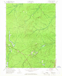
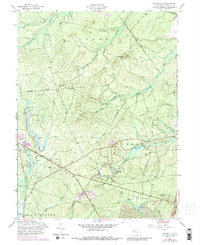
1957 Map of Brookville
USGS Topo · Published 1966About this map
The Pinelands of Ocean County reveal a landscape of low-lying waterways and early industrial remnants in the mid-1950s. Named settlements like Brookville and Howardsville are situated among a network of branches feeding the Forked River and Wading River. The cultivation of local wetlands is evident through numerous Cranberry Bogs scattered throughout the lowlands, particularly near East Branch Wading River. Higher ground is marked by Forked River Mtn, while a prominent Lookout Tower and several other Towers suggest the importance of fire observation and communication in this wooded region.
Find a feature on this map
33 named features on this map. Tap any name to fly to it.
Don’t see what you’re looking for? This feature index may not catch every label — zoom into the map to look around manually.
Map Details
Editions of this 1957 Brookville Map
5 editions found
Other maps of this area

1884 · Whitings
USGS Topo · 1:62,500

1888 · Barnegat
USGS Topo · 1:62,500

1888 · Little Egg Harbor
USGS Topo · 1:62,500

1888 · Long Beach
USGS Topo · 1:62,500

1888 · Whitings
USGS Topo · 1:62,500

1893 · Little Egg Harbor
USGS Topo · 1:62,500

1893 · Long Beach
USGS Topo · 1:62,500

1893 · Barnegat
USGS Topo · 1:62,500

1898 · Barnegat
USGS Topo · 1:62,500

1919 · Long Beach
USGS Topo · 1:62,500