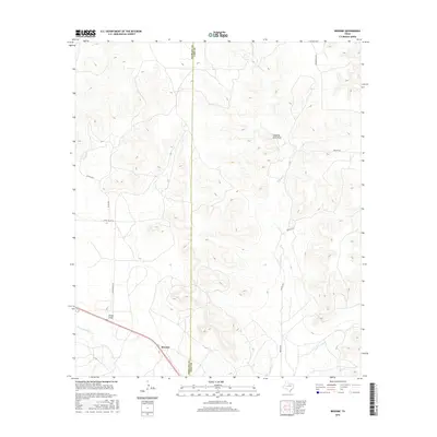
2016 Map of Broome
USGS Topo · Published 2016About this map
Broome stands at the southern edge of this West Texas landscape, where the N Concho River cuts through the arid terrain of the Edwards Plateau. The settlement sits near the confluence of several seasonal drainage systems, most notably China Draw, which shapes the local topography south of the Sterling Co Coke Co boundary line. This 2016 survey illustrates a sparsely populated region defined by large-scale ranching and land management, with a network of rural routes such as China Valley Ln and Walnut Rd providing access to interior pasturelands.
Find a feature on this map
12 named features on this map. Tap any name to fly to it.
Don’t see what you’re looking for? This feature index may not catch every label — zoom into the map to look around manually.
Map Details
Editions of this 2016 Broome Map
This is the sole edition of this map. No revisions or reprints were ever made.
Other maps of this area

1954 · San Angelo
USGS Topo · 1:250,000

1957 · Carlsbad
USGS Topo · 1:62,500

1958 · San Angelo
USGS Topo · 1:250,000

1962 · Green Mountain
USGS Topo · 1:24,000

1965 · San Angelo
USGS Topo · 1:250,000

1972 · Sterling City
USGS Topo · 1:24,000

1972 · Dog Creek NE
USGS Topo · 1:24,000

1972 · Broome
USGS Topo · 1:24,000
1972 · Crawford Slide
USGS Topo · 1:24,000
1972 · Sterling City NW
USGS Topo · 1:24,000