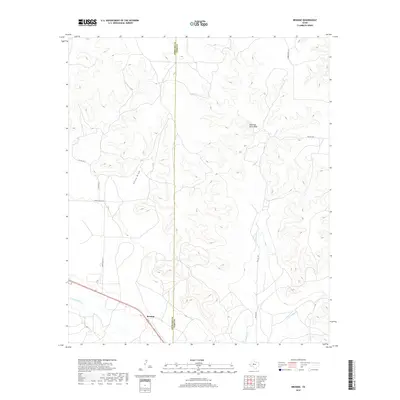
2019 Map of Broome
USGS Topo · Published 2019About this map
Broome sits in the southwestern portion of this West Texas landscape, positioned where the N Concho River and several ephemeral drainage systems converge. The terrain is defined by the sharp transition between the river valley and the higher plateaus, most notably at the Shelving Rock Bluff. This area, straddling the Sterling Co and Coke Co boundary, exhibits a sparse network of roads like Walnut Rd and China Valley Ln that navigate the draws and canyons. The drainage patterns of Walnut Cr, Little Walnut Cr, and China Draw illustrate the hydrologic character of the Edwards Plateau region, showing how seasonal water flow has carved the distinctive topography over time.
Find a feature on this map
13 named features on this map. Tap any name to fly to it.
Don’t see what you’re looking for? This feature index may not catch every label — zoom into the map to look around manually.
Map Details
Editions of this 2019 Broome Map
This is the sole edition of this map. No revisions or reprints were ever made.
Other maps of this area

1954 · San Angelo
USGS Topo · 1:250,000

1957 · Carlsbad
USGS Topo · 1:62,500

1958 · San Angelo
USGS Topo · 1:250,000

1962 · Green Mountain
USGS Topo · 1:24,000

1965 · San Angelo
USGS Topo · 1:250,000

1972 · Sterling City
USGS Topo · 1:24,000

1972 · Dog Creek NE
USGS Topo · 1:24,000

1972 · Broome
USGS Topo · 1:24,000
1972 · Crawford Slide
USGS Topo · 1:24,000
1972 · Sterling City NW
USGS Topo · 1:24,000