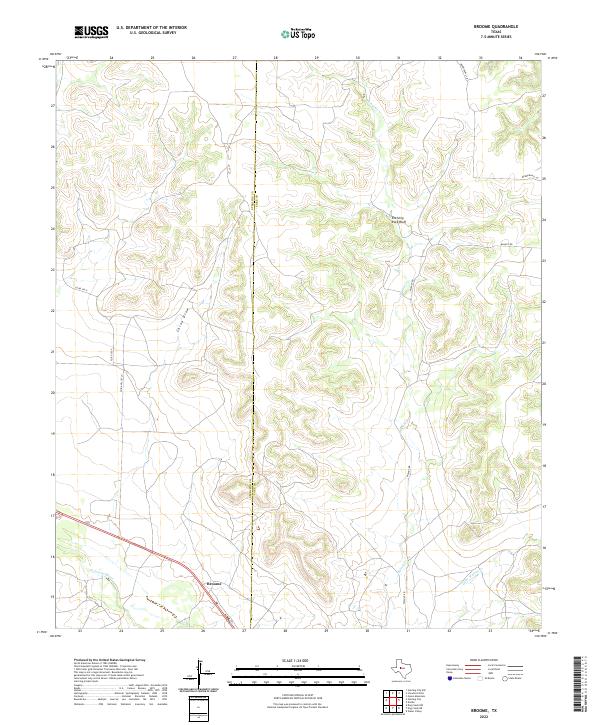
2022 Map of Broome
USGS Topo · Published 2022About this map
Broome occupies a point along the southern edge of this West Texas landscape, where the N Concho River flows through the lowlands. The terrain is defined by the sharp verticality of Shelving Rock Bluff and the carved drainage of China Draw, illustrating the erosional patterns common to the Edwards Plateau. The boundary between Sterling Co and Coke Co runs vertically through the center of the sheet, dividing a region characterized by ranching access roads like Walnut Rd and China Valley Ln. The intricate network of seasonal waterways, including Walnut Cr and Little Walnut Cr, shows how the landscape is segmented by dry creeks that shape the movement of people and livestock in this portion of Coke County.
Find a feature on this map
13 named features on this map. Tap any name to fly to it.
Don’t see what you’re looking for? This feature index may not catch every label — zoom into the map to look around manually.
Map Details
Editions of this 2022 Broome Map
This is the sole edition of this map. No revisions or reprints were ever made.
Other maps of this area

1954 · San Angelo
USGS Topo · 1:250,000

1957 · Carlsbad
USGS Topo · 1:62,500

1958 · San Angelo
USGS Topo · 1:250,000

1962 · Green Mountain
USGS Topo · 1:24,000

1965 · San Angelo
USGS Topo · 1:250,000

1972 · Sterling City
USGS Topo · 1:24,000

1972 · Dog Creek NE
USGS Topo · 1:24,000

1972 · Broome
USGS Topo · 1:24,000
1972 · Crawford Slide
USGS Topo · 1:24,000
1972 · Sterling City NW
USGS Topo · 1:24,000