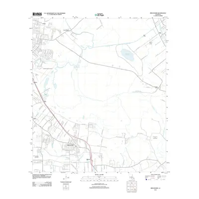
2012 Map of Broussard
USGS Topo · Published 2012About this map
Broussard and its surrounding communities are defined by a complex network of waterways and infrastructure in this early 21st-century landscape. The Vermilion River and Evangeline Canal anchor the drainage patterns of the region, while the Cypress Island Oil and Gas Field indicates the ongoing industrial importance of the terrain. The map details the transition from the aviation hubs of Lafayette Regional Airport and Spillers Club Airport to the smaller settlements of Billeaud, Pilette, and Elks. Suburban expansion is visible through an extensive grid of residential roads, yet the presence of Lake la Pointe and Bayou Teche reflects the enduring natural hydrology of Lafayette Parish. Local recreation is represented by Les Vieux Chenes Municipal Golf Course, highlighting the mix of civic development and natural bayous that characterize this portion of southern Louisiana.
Find a feature on this map
98 named features on this map. Tap any name to fly to it.
Don’t see what you’re looking for? This feature index may not catch every label — zoom into the map to look around manually.
Map Details
Editions of this 2012 Broussard Map
This is the sole edition of this map. No revisions or reprints were ever made.
Other maps of this area

1939 · St. Martinsville
USGS Topo · 1:62,500

1940 · Arnaudville
USGS Topo · 1:62,500

1946 · Milton
USGS Topo · 1:31,680

1946 · Lafayette
USGS Topo · 1:31,680

1952 · Lake Charles
USGS Topo · 1:250,000

1954 · Lafayette
USGS Topo · 1:31,680
1954 · Milton
USGS Topo · 1:31,680

1954 · Lake Charles
USGS Topo · 1:250,000

1954 · Baton Rouge
USGS Topo · 1:250,000

1955 · Lafayette
USGS Topo · 1:24,000