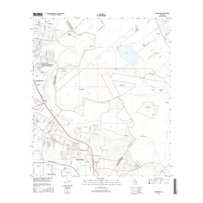
2015 Map of Broussard
USGS Topo · Published 2015About this map
The Vermilion River and Bayou Tortue weave through the heart of this Acadiana landscape, defining a region where urban expansion meets historic watercourses. In the southwest, Broussard and Youngsville show significant suburban development, while the northern reaches maintain a more open character near Larabee and Ruth. The presence of the Jean Lafitte National Historical Park and Preserve highlights the area's ecological and cultural importance. Regional infrastructure is anchored by the Lafayette Regional Airport, with aviation history further represented by smaller sites like Spillers Club Airport. Water management and drainage are evident through features such as the Evangeline Canal and Ruth Canal, which connect to natural features like Lake la Pointe. This map documents a transitional period as the Lafayette metro area extends toward established settlements like Billeaud and Pilette.
Find a feature on this map
40 named features on this map. Tap any name to fly to it.
Don’t see what you’re looking for? This feature index may not catch every label — zoom into the map to look around manually.
Map Details
Editions of this 2015 Broussard Map
This is the sole edition of this map. No revisions or reprints were ever made.
Other maps of this area

1939 · St. Martinsville
USGS Topo · 1:62,500

1940 · Arnaudville
USGS Topo · 1:62,500

1946 · Milton
USGS Topo · 1:31,680

1946 · Lafayette
USGS Topo · 1:31,680

1952 · Lake Charles
USGS Topo · 1:250,000

1954 · Lafayette
USGS Topo · 1:31,680
1954 · Milton
USGS Topo · 1:31,680

1954 · Lake Charles
USGS Topo · 1:250,000

1954 · Baton Rouge
USGS Topo · 1:250,000

1955 · Lafayette
USGS Topo · 1:24,000