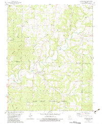
1982 Map of Brownbranch
USGS Topo · Published 1983About this map
Beaver Creek and its many tributaries, including Little Brown Branch and Caney Creek, carve through the Ozark landscape of Douglas and Taney counties. The settlement of Brownbranch serves as a central point in this rural area, supported by outlying communities like Rome and McClurg. The map reveals a dense network of family and community landmarks, particularly evident in the high concentration of burial grounds such as Summers Cem, Watterson Cem, and Eldridge Cem. Education and faith were central to local life, anchored by the Plainview R-8 Sch and several country churches like Union Grove Ch and Sandy Ch. Much of the southern portion is preserved as part of the Mark Twain National Forest, where the terrain rises into the Buchanan Hills and the Walker Homestead.
Find a feature on this map
42 named features on this map. Tap any name to fly to it.
Don’t see what you’re looking for? This feature index may not catch every label — zoom into the map to look around manually.
Map Details
Editions of this 1982 Brownbranch Map
This is the sole edition of this map. No revisions or reprints were ever made.
Other maps of this area

1936 · Thornfield
USGS Topo · 1:48,000

1936 · Ava
USGS Topo · 1:48,000

1937 · Bradleyville
USGS Topo · 1:48,000

1942 · Ava
USGS Topo · 1:62,500

1943 · Protem
USGS Topo · 1:62,500

1943 · Thornfield
USGS Topo · 1:62,500

1943 · Bradleyville
USGS Topo · 1:62,500

1945 · Ava
USGS Topo · 1:62,500

1945 · Harrison
USGS Topo · 1:250,000

1945 · Thornfield
USGS Topo · 1:62,500