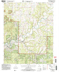
2004 Map of Brownbranch
USGS Topo · Published 2006About this map
Beaver Creek meanders through this portion of the Ozark highlands, defining a landscape shaped by creek-side settlements and high-ridge roads. Small communities such as Brownbranch and Rome occupy the valley floors, while historic centers like Cross Roads sit at higher elevations. The area is dense with family and community burial grounds, from the Summers Cem in the north to the Eldridge Cem near the southern border, reflecting a deeply rooted rural genealogy. Social life is anchored by traditional institutions like Sandy Ch and the Plainview R-8 Sch. Much of the southern terrain is protected within the Mark Twain National Forest, where the Glade Top Trail Scenic Byway follows the ridgelines, offering a look at the interplay between timbered forest lands and the dispersed farmsteads of the Douglas and Taney county line.
Find a feature on this map
54 named features on this map. Tap any name to fly to it.
Don’t see what you’re looking for? This feature index may not catch every label — zoom into the map to look around manually.
Map Details
Editions of this 2004 Brownbranch Map
This is the sole edition of this map. No revisions or reprints were ever made.
Other maps of this area

1936 · Thornfield
USGS Topo · 1:48,000

1936 · Ava
USGS Topo · 1:48,000

1937 · Bradleyville
USGS Topo · 1:48,000

1942 · Ava
USGS Topo · 1:62,500

1943 · Protem
USGS Topo · 1:62,500

1943 · Thornfield
USGS Topo · 1:62,500

1943 · Bradleyville
USGS Topo · 1:62,500

1945 · Ava
USGS Topo · 1:62,500

1945 · Harrison
USGS Topo · 1:250,000

1945 · Thornfield
USGS Topo · 1:62,500